DEDHAM, Mass. — A rare, late-spring nor’easter is expected to slam Massachusetts on Thursday with torrential rain, powerful wind gusts, and threaten coastal communities with flooding ahead of Memorial Day weekend.
The Boston 25 Weather Team issued a WEATHER ALERT due to the storm’s expected impacts.
“We’re going to see peak wind and rain this afternoon and evening,” Boston 25 Meteorologist Shiri Spear said her latest forecast. “Absolute downpours out there.”
Downpours, gusty wind, and coastal flooding (minor) will peak this afternoon & evening in southern #NewEngland #mawx #boston @boston25 pic.twitter.com/dyEd4momEd
— Shiri Spear (@ShiriSpear) May 22, 2025
LATEST STORM TIMELINE
Steady rain will be in place for the morning commute, with rainfall turning heavier after about 8 a.m.
Downpours will soak the region from midday through the afternoon and evening.
Spear warned that travel will be slow, with low visibility and ponding water on area roads.
Showers could linger through Friday and there will be a chance for a spot shower on Saturday, but conditions will track mostly dry by then.
Sunday will be dry, but cloudy.
THREATS WE’RE WATCHING
- 1-3 inches of rain
- Wind gusts 30 to 50 mph
- Areas of coastal flooding

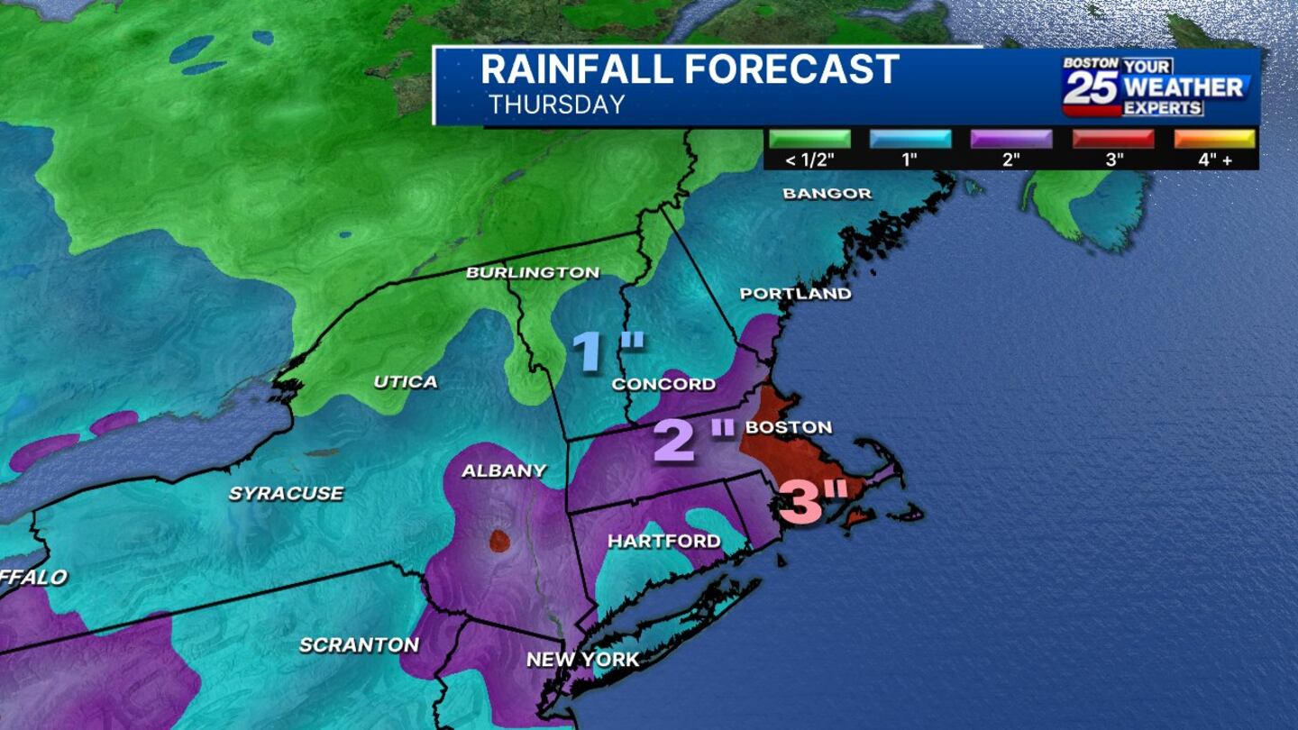
EXPECTED RAINFALL TOTALS
Rainfall totals of up to 2.5 inches is likely across most of Massachusetts.
Some communities in eastern Massachusetts could see up to 3 or 4 inches of rain by Thursday night.
Northern new England, including New Hampshire, Maine, and Vermont will see about an inch of rain.
STRONG WIND
Wind gusts will ramp up as well on Thursday, also peaking in the afternoon and evening.
Gusts of 40-50 mph will develop along the coast, highest on Cape Cod, Nantucket, and Martha’s Vineyard
Inland gusts will range from 30-40 mph.
The National Weather Service issued a wind advisory for Essex, Suffolk, Norfolk, Plymouth, Barnstable, Dukes, and Nantucket counties.
There is a risk of wind damage and power outages, as with any powerful storm.
“The fact that the trees are fully leaved and the soil is saturated will enhance the risk for tree damage and some power outages,” Spear wrote in her latest weather blog.

FLOODING THREAT
Pockets of splash over and minor coastal flooding will develop late Thursday afternoon and evening along the coast ahead of the 8 p.m. high tide.
The National Weather Service issued a coastal flood advisory for Bristol, Plymouth, Essex, Suffolk, Norfolk, Plymouth, Barnstable, Dukes, and Nantucket counties.
Flooding of lots, parks, and roads with isolated closures are expected.
“If travel is required, allow extra time as some roads may be closed. Do not drive around barricades or through water of unknown depth. Take the necessary actions to protect flood-prone property,” the NWS warned.
EARLY SPRING FEEL
Highs on Thursday will be in the 40s and low 50s.
Temps will climb into the lower 60s in some areas this weekend.
Memorial Day is shaping up to be partly cloudy with temperatures climbing back near 70 degrees.
STAY UPDATED
For more on the forecast, visit the Boston 25 Weather page.
Download the FREE Boston 25 News app for breaking news alerts.
Follow Boston 25 News on Facebook and Twitter. | Watch Boston 25 News NOW
©2025 Cox Media Group
/cloudfront-us-east-1.images.arcpublishing.com/cmg/7QOJU3BNCJERBNKJC5LWTBYFLU.png)


