WESTPORT, Mass. — Several Massachusetts beaches have been closed to swimming as monstrous Hurricane Erin moves north in the Atlantic Ocean, churning up high surf and treacherous rip currents.
The closures affect several beaches along the southern coast of the Bay State, with Horseneck Beach in Westport prominently displaying signs prohibiting entry to the parking lot.
#NOW Beaches in Westport are closed due to high surf and rip currents as Massachusetts feels impacts of Hurricane Erin pic.twitter.com/MEmPqKTZp7
— Alyssa Azzara (@alyssaazzaraTV) August 21, 2025
Serious threat to swimmers
The National Weather Service has issued a forecast warning of rip currents that can pull swimmers away from the shore and into deep water, Massachusetts Gov. Maura Healey reminded residents.
“I want to urge everyone on our coasts to stay safe and alert as we expect to experience some effects of the storm passing offshore,” Healey said in a statement. “Rip currents and high surfs are a serious threat to swimmers. Please be careful while the storm passes through our region and keep an eye out for neighbors who might need assistance.”
Many of the Department of Conservation and Recreation beaches are within the “High Risk” area of the NWS’s surf zone forecast. High surf advisories are currently in effect through Friday and could extend into the weekend.
Erin could regain strength
Hurricane Erin battered North Carolina’s Outer Banks with strong winds and waves that flooded part of the main highway and surged under beachfront homes on Wednesday.
While Erin won’t make landfall in New England, forecasters said it could regain strength and once again become a major hurricane, Category 3 or greater, on its trek north.
Erin remained a Category 2 hurricane early Thursday with maximum sustained winds around 105 mph. It’s tropical storm-force winds spread across 500 miles, roughly the distance from New York City to Pittsburgh.
It will make its closest pass at Massachusetts on Thursday night.
We'll see #HurricaneErin pass over 200 miles off the coast of MA tonight, but waves & marine conditions will be VERY DANGEROUS. #ack & #mvy will take the brunt of the minor coastal flooding & beach erosion. @boston25 pic.twitter.com/wp8N6rEjXW
— Shiri Spear (@ShiriSpear) August 21, 2025
High surf advisory in effect
The NWS has issued a high surf advisory for Essex, Plymouth, Bristol, Dukes, Nantucket, and Barnstable counties through Saturday at 8 p.m.
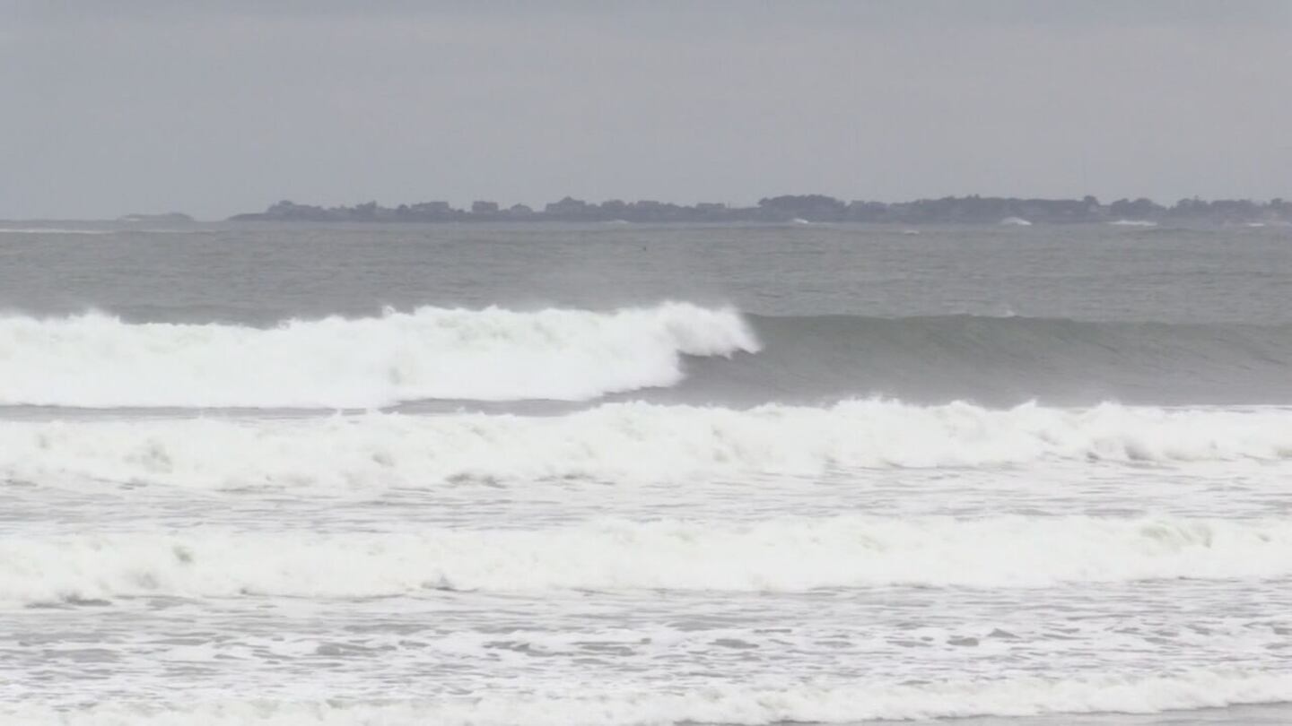
In the impacted surf zones, the NWS warned of large breaking waves anywhere from 4 to 20 feet in height.
Wave heights are expected to peak on Thursday night, and the presence of double red flags on the beach indicates that swimming is strictly prohibited.
“Those waves out there are super powerful, but also what they’re doing is paving a path for rip currents,” DCR lifeguard Jillian Boyle said. “As these waves are crashing on shore, they’re creating those narrow channels. That’s going to be what we’re going to start to see over the coming days and even after the storm has passed us, these really nasty rip currents.”
Officials urged inexperienced swimmers to remain out of the water due to the dangerous surf conditions
Flooding is possible along the coast
A coastal flood advisory has also been issued for the same areas through early Saturday morning.
“If travel is required, allow extra time as some roads may be closed. Do not drive around barricades or through water of unknown depth. Take the necessary actions to protect flood-prone property,” the NWS advised.
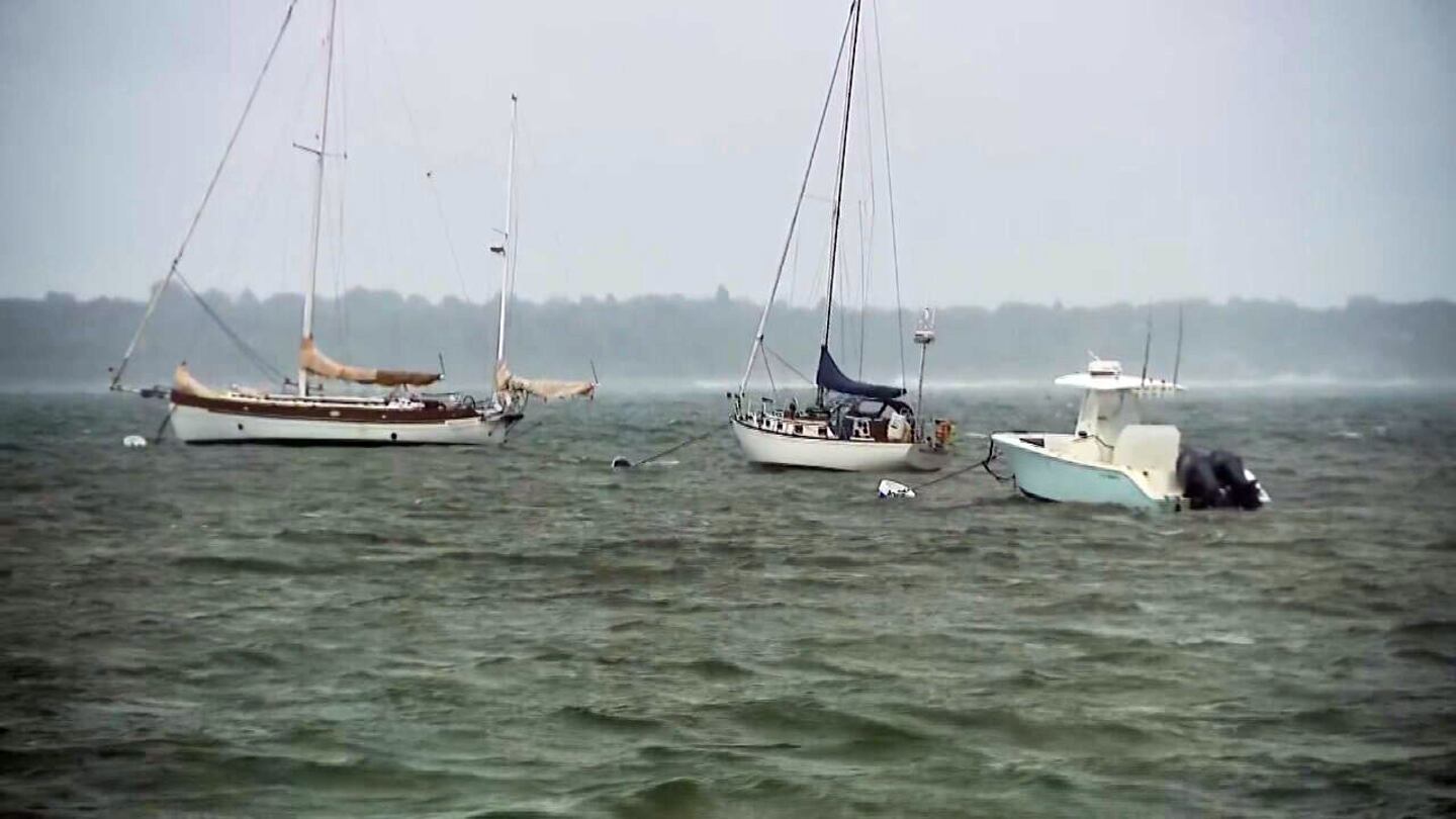
Fishermen and boaters urged to use caution
The Division of Marine Fisheries is urging shore-based anglers to be vigilant of high surf conditions that can make areas unsafe for fishing. Mariners should also review marine forecasts.
A gale watch will be in effect Thursday morning through late Friday night. Boaters should consider altering plans to avoid reduced visibility and potentially damaging winds.
While Hurricane Erin will pass offshore, it's expected to bring hazardous conditions to MA coastal waters & beaches.
— MEMA (@MassEMA) August 20, 2025
🛥️ Small Craft Advisory & Gale Watch – Boaters should alter plans to avoid dangerous conditions
🌊 High Surf Advisory – Avoid swimming due to dangerous surf pic.twitter.com/2GZ7dgpYgW
Wind advisory for the Cape and the Islands
Gusty winds will also be a factor, especially Friday into Saturday.
A wind advisory is in effect until 2 p.m. Friday for Barnstable, Nantucket, and Dukes counties.
Northeast winds 15 to 25 mph with gusts up to 45 mph are expected.
“Gusty winds will blow around unsecured objects. Tree limbs could be blown down, and some power outages may result,” the NWS warned. “Winds this strong can make driving difficult, especially for high-profile vehicles.”
The Boston 25 Weather team will continue to track Erin, providing updates online and on-air.
Download the FREE Boston 25 News app for breaking news alerts.
Follow Boston 25 News on Facebook and Twitter. | Watch Boston 25 News NOW
©2025 Cox Media Group
/cloudfront-us-east-1.images.arcpublishing.com/cmg/7QOJU3BNCJERBNKJC5LWTBYFLU.png)


